

Ads by Google

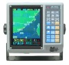
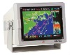
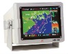
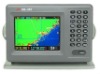
FUNCTION INTRODUCTION
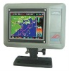
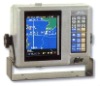
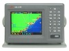
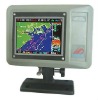
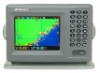
Satallite Navigation
Track: 25000 points Destination:300 Marks set:2000 Water lines:7Map, Track Storage
Fish-zone map Solar calendar/lunar calendar Simulation electron compass Satellite informationSPECIFICATION
Machine Size: 256mm X 180mm X 95mm(including machine foot ) Color LCD: 320*240 display points Ambient temperature:-10°C-+40°C GPS re-position time: 30 seconds or less Geodesic of the WGS-84 (based on user requirements, can be set to test other lines) Speed precision: 0.1 knots, heading accuracy: 1 ° Speed data can be an average of 16 stalls, derection data an average of 32 stalls Bathymetric temperature accuracy: 0.1 °C The average time of charts redraw :less than 1 second Can store track points: 25000 points, 7 color options Destination can be set (route points): 300 Finalized marks can be set (of points): 2000, 9 kinds of shape options Route : 20 Input and output interface specification: NMEA-0183 Input voltage: DC11-33V (standard DC+13.8V) Charts ratio:0.01NM-500NM Isobath (water lines) 8, of which one fixed, seven options screen display: 1.map navigation; 2.compass 3.data navigationSTANDARD LAYOUTusage manual 633/689/636machine foot output line NMEA-0183 5V satellite navigation ANT used in boat 3A power lineHR-633B Satellite Navigation\Plotter Track