
Ads by Google


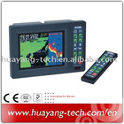
ONWA®
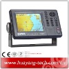
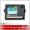
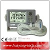
MARINE 5.6”TFT LCD GPS CHART PLOTTER
MODEL: KP-6288
FEATURE:
1. High resolution 5.6 inches day-view LCD display
2. Works with C-map Max NT Chart (SD) and Onwa K-Chart
3. Quick chart drawing speed
4. Proximity waypoint alarm
5. Versatile display modes including:
- Course Plot - Nav Data
- Steering Display - Highway
6. High performance GPS receiver
7. User SD card to save and transfer waypoint, track, route memory
8. Course plot in North-up, Course-up or Waypoint Up
9. Tide Table
10. “Goto Track” let you retrace your path in both directions
SPECIFICATIONS
Plotter Characteristics
1. Display: 5.6-inches color TFT day-view LCD 320 × 240 pixels
2. Projection: Mercator projection
3. Map Scale: 0.06nm to 500nm
4. Plot Interval: 5s to 60h or 0.01nm to 10.0nm
5. Presentation Mode: North Up, Bow Up, Waypoint Up
6. Track Memory: 30,000 point automatic track log: 15 saved track (up to 2,000 track points each) let you retrace your path in both directions
7. Waypoint Memory: 15,000 waypoints with name
8. Route Memory: 30 reversible routes with up to 200 points each, plus MOB and Track Navigation or Goto Track modes
9. Alarm: XTE, Anchor Drag, Arrival, Speed, Voltage, Proximity, Waypoint and Time
10. Nav Data Input/Output:
1) Input:
$--DBT, $--DPT, $--GGA, $--GLL, $--MTW, $--RMA, $--RMB, $--RMC, $--VHW, $--VTG, $--ZDA
2) Output:
$--AAM, $--APB, $--BOD, $--BWC, $--GGA, $--GLL, $--RMB, $--RMC, $--VTG, $--XTE, $--ZDA, $--WPL, $--HDG
3) Output for autopilot:
$--AAM, $--APB, $--BOD, $--VTG
11. Proximity Waypoint 10 proximity waypoint
PALLETE
Daylight: Exposed to sunlight
Night: In dark environment
NOAA: Paper chart color
Memory
1. External SD Cards Two SD Cards slot for C-map MAX and User SD memory card
2. Internal Memory Built-in Onwa K-Chart
GPS Receiver Characteristics
1. Accuracy: Position: <15 meters(95%) without S/A
Velocity: 0.1 meter/sec without S/A
Time: ±100ns synchronized to GPS time
2. Acquisition: Cold start: 60 seconds average
Warm start: 45 seconds average
Hot start: 15 seconds average
3. Dynamics: Altitude: 18,000m Max
Velocity: 500 m/s
Acceleration: 4g Max
4. Datum: WGS 84
Physical
1. Size: 228mm(H) × 138mm(W) × 79mm(D)
2. Weight: 0.9kg
Environment
1. Temperature: -15°C to + 55°C (Display unit)
-25°C to + 70°C (GPS antenna)
2. Water proofing: Display unit: IPX5
Antenna unit: IPX6
Power Supply
1. Power supply: 10.5 to 35 VDC
2. Current drain: 0.3A at 12V; 0.16A at 24V
Equipment List (Standard)
- Display unit
- Antenna unit with 10m cable
- Operator manual
- Installation materials
- Standard spare parts
GPS CHART PLOTTER SD C-MAP marine